Port Stephens – a land formed by fire and ice
by Neil Fraser, Geologist (retired).
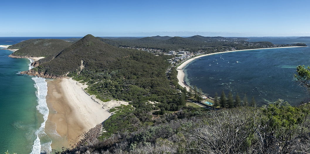
Visitors to Port Stephens who climb to the top of Tomaree Head are presented with a stunning view of a range of low hills extending to the north-west, surrounded by coastal lowlands and dunes that extend north and south to the horizon. However, this tranquil vista of wooded hills, rocky islands and pristine sandy beaches that make up Port Stephens today belies the violent events that led to their formation, millions of years ago.
To understand the geological history of our region, we must first look for current day analogues. Australia is a very old continent and the last major mountain-building phase occurred 250-200 million years ago, so we must look to other regions where similar processes are occurring today.
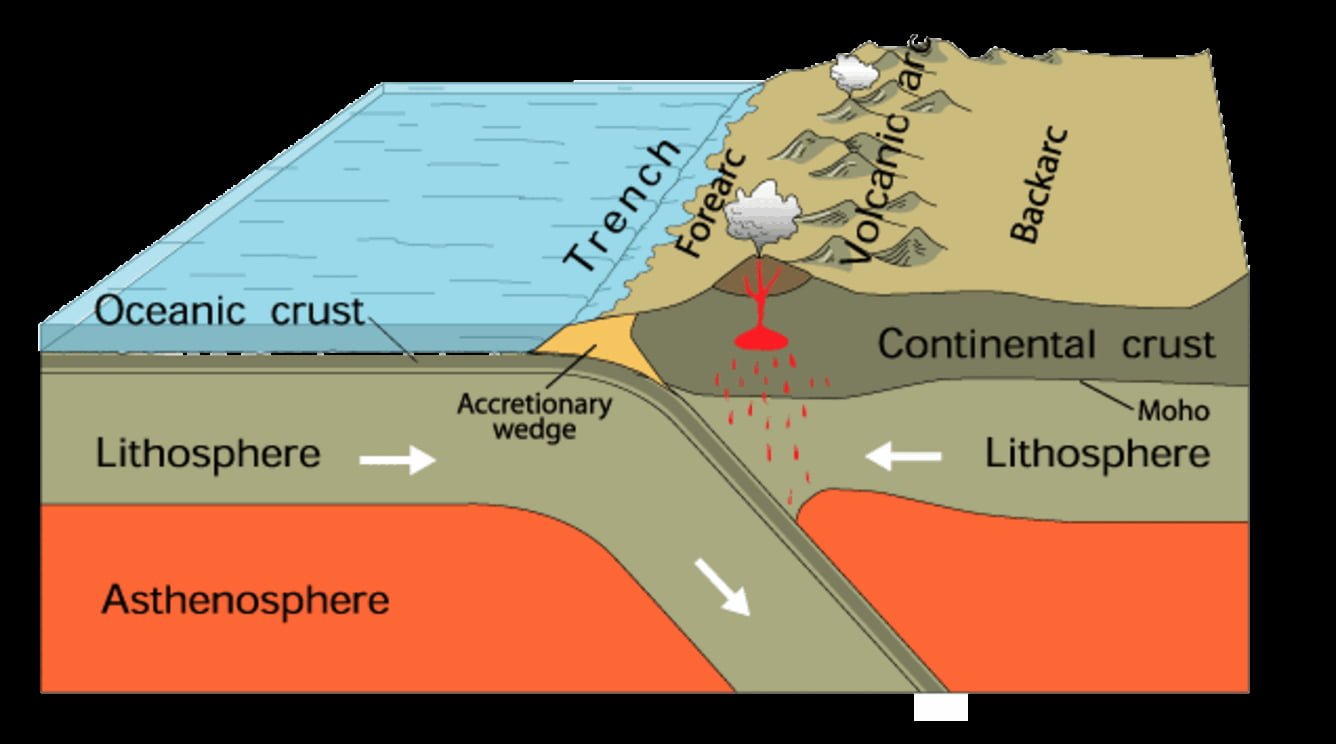
At the time our region was being formed around 340 million years ago, it was located on the proto-East Australian continental margin which at that time was part of the ancient Gondwana supercontinent. The continental margin was made up of an extensive chain of volcanoes (volcanic arc) fronted by a deep ocean trench. Here, a section of thin oceanic crust was being subducted beneath the continental crust by plate tectonic processes. Water-bearing sediments that had accumulated in the trench, plus oceanic crust, were thrust to depths of 100 km where the higher temperatures and pressures enabled melting to occur, forming magmas. The hot buoyant magmas rose to the surface, erupting to form a volcanic arc. The closest analogue today is the Indonesian archipelago to our north which comprises over 5,000 islands forming part of the Pacific Ring of Fire. There are over 400 volcanoes along the island chain and around 130 of these are active.
While the eruptions that occur along these volcanic arcs produce mainly ash and lava flows, they are at times accompanied by violent explosions. These explosions are caused when magma encounters water and produces superheated steam. The force of the expanding gases results in volcanic material being ejected at speeds of several hundred metres per second, and eruption plumes generated that extend tens of kilometres high into the stratosphere. These high-altitude ash clouds can impact global weather patterns for years. The eruptions also generate pyroclastic flows (Greek: fire, broken), a dense, destructive mass of very hot ash, lava fragments and gases which flow down the slopes of the volcano at speeds of several hundred kilometres per hour. These flows have been known to travel 10-100s of km from the eruption site. The temperature of the erupted material can vary from 200-700°C, and when it exceeds 535°C, it becomes welded into solid rock. This rock type is known as ignimbrite (Latin: fire rain). At the completion of the eruption, a caldera (Latin: boiling pot) is typically formed by the partial collapse of the volcano following the release of its magma, forming a large depression.

These explosive eruptions are known as Plinian eruptions, and are named after Pliny the Younger (CE 61-113), a lawyer, author and magistrate of ancient Rome. Pliny’s uncle, Pliny the Elder, helped raise and educate him. When Pliny the Younger was 17 or 18 in CE 79, he witnessed the eruption of Mount Vesuvius which destroyed Pompeii and Herculaneum. The eruption produced an ash column 33 km high and more than 1,000 people perished. He subsequently wrote two detailed accounts of the eruption that have survived to this day. His uncle Pliny the Elder died while attempting to rescue victims of the eruption. Other well-known recent examples are Mount Tambora and Krakatau in Indonesia, Mt. Pinatubo in the Philippines, the Lake Taupo eruption in New Zealand and Mount St. Helens in the USA. The best documented of these eruptions is Mount St. Helens in Washington State, USA which erupted in May 1980. It resulted in 57 deaths, caused $US1.1 billion in property damage ($US3.3 billion in 2022), blasted 4.2 km3 of material from the volcano’s flanks and produced an ash cloud 68 km wide and 24 km high. The eruption was captured on the video and can be viewed on this link to Encyclopedia Britannica Inc.
The building of a continent
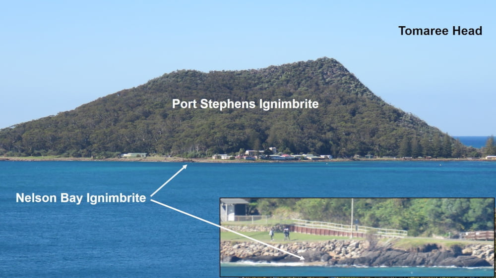
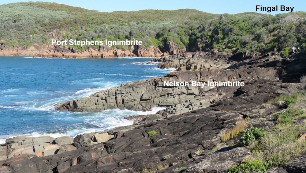
In the Port Stephens region there are two major ignimbrite units that were formed by explosive volcanic activity along the proto-East-Australian continental margin when the area was part of a volcanic arc. The lower unit is known as the Nelson Bay ignimbrite and tends to be more subdued in outcrop than the more prominent upper unit, known as the Port Stephens ignimbrite. The latter unit forms all the hills around Port Stephens.
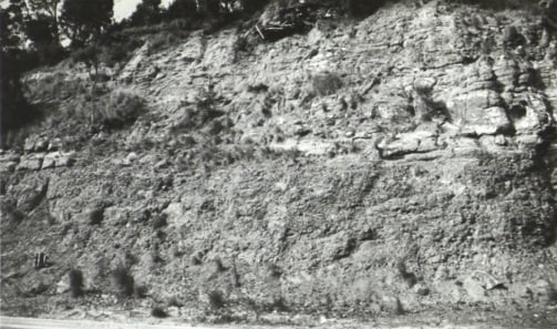
The Nelson Bay ignimbrite is around 165m thick and dark grey in appearance. It most prominently outcrops along the shoreline at the southern end of Fingal Bay. A small outcrop is present on the shoreline of Shoal Bay in front of the Tomaree Lodge. There are other outcrops along the shoreline of Nelson Bay and at Corlette Point. The unit also outcrops on the north side of Yacaaba Head, below the Port Stephens ignimbrite. The Nelson Bay ignimbrite is dacitic in composition and the major mineral components are plagioclase, hornblende and hypersthene.

Bottom: Nelson Bay Ignimbrite outcrop at the base of Yacaaba Head north side.
The Port Stephens ignimbrite overlies the Nelson Bay ignimbrite and is the result of a subsequent explosive eruption. It is around 190m thick and has a reddish-brown appearance. Because it is composed of minerals with a higher silica content than the underlying Nelson Bay ignimbrite, it is less resistant to erosion. All the hills around Port Stephens, the islands outside the heads and inside the port are composed of this rock type. It is rhyolitic in composition and the major mineral components are quartz, plagioclase and potassium-feldspar. A sample of the ignimbrite from Kingsley Beach, Boat Harbour was age dated at 340.5 ± 2 million years. Age dating is conducted by measuring the rations of the radioactive isotopes of uranium and lead in zircons. Zircons is a highly stable mineral present in minute amounts in the volcanics.
One item of particular interest in the local volcanic sequence is the presence of thin, highly silica rich flows containing volcanic glass. These occur within the Port Stephens ignimbrite on the foreshore at Fly Point and at Nelson Head. The outcrop at Fly Point has been age dated at 332 ± 4 million years.

The interval between the eruption of the Nelson Bay ignimbrite and the Port Stephens ignimbrite is unknown but it could have been from hundreds of years to thousands of years. In that intervening period the Nelson Bay ignimbrite was weathered and eroded into a series of hills and small valleys. Volcanoclastic sediments including conglomerate, sandstone and shale, derived from the ignimbrite, were deposited in the valleys. Plant fossils are present in these sediments at Soldiers Point.
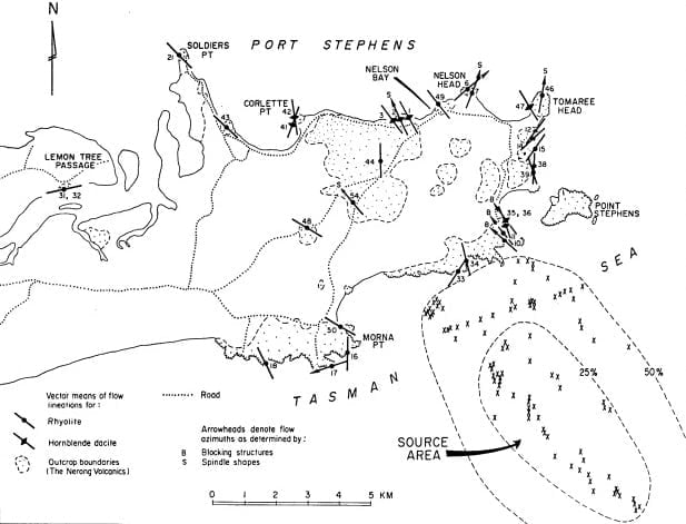
The ignimbrites and their associated volcanoclastic sediments are collectively known as the Nerong Volcanics. This unit extends from Birubi Point, 45 km north to Booral. By analysing the orientation of the flow induced lineation of crystals and pumice clasts it is possible to determine the source of the ignimbrites. The eruptive centre was determined to have been located 5 km southeast of Morna Point. The material erupted was estimated to be 205 km3 and the resultant caldera 10 km in diameter.

Due to its high silica content, the Port Stephens ignimbrite is hard and very resistant to erosion, making it an ideal material for construction purposes. All the existing hard rock quarries in the region, Karuah East, Brandy Hill, and Balickera, and proposed quarries at Stone Ridge, Deep Creek and Eagleton, are located within this unit.
Dykes
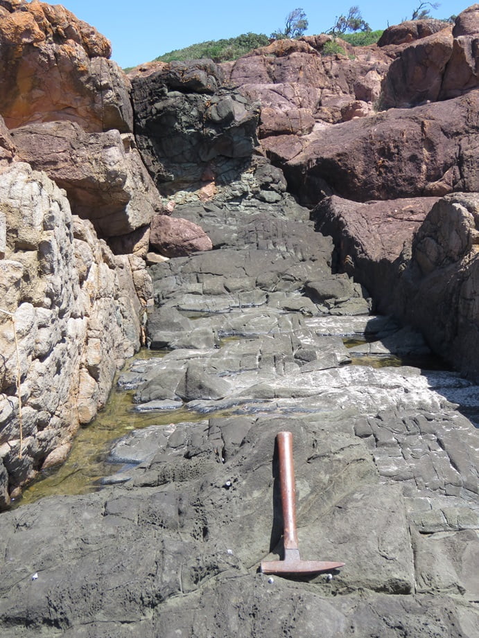
The accretionary process involved in the evolution of the proto-East-Australian continental margin continued for around another 50 million years. However, the resultant strata are not present in the immediate Port Stephens area. They were probably eroded. The next episode of geological activity preserved in the area are a series of dykes (Old Norse: ditch) which are exposed along the coastline. Dykes are tabular or sheet-like bodies of magna that intrude older rocks. They are generally vertical or near vertical and form when magma rises into an existing fracture or joint and solidifies. They are mostly basaltic composition. Between Cemetery Point and Fingal Bay there are 57 dykes from a few cm to 5 m wide. Due to their mineralogy, basaltic dykes are often less resistant to erosion than the surrounding rocks and are often present as elongate depressions.
The time period in which the dykes were intruded is uncertain. Throughout the Hunter Region they vary in age from 266 to 53 million years. The majority were intruded less than 84 million years ago.

The recent geology of Port Stephens
The most recent geological activity around Port Stephens resulted is the formation of widespread coastal lowlands and wetlands over the past few thousand years. To understand these events, we must look at what was occurring during the Pleistocene (Latin: most recent) period of geological time, which extended from 2.58 million years until 12,000 years ago. This period is also known as the Ice Ages. During this period glaciers and ice sheets cover 8% of the Earth’s surface and 25% of the land. They were 17 glacial episodes approximately 100,00 years apart, mostly in the Northern Hemisphere, although Tasmania and parts of the Kosciusko Plataea were glaciated.
The last Glacial Maximum occurred approximately 20,000 years ago. Much of the Earth’s water had become incorporated into the northern ice sheets and the sea level was about 120 m below current level. The Glacial Maximum was followed by a marine transgression (rising sea level) and from about 18,000 years ago, sea levels rose by around one metre per century until the current level was reached about 8,000 years ago. All the low-lying areas around Port Stephens were covered by sediments deposited during this last post glacial marine transgression.
The typical sedimentary sequence formed during a marine transgression is as follows. Initially, rising seas encroach onto adjacent coastal areas flooding estuaries and forming coastal lagoons. During this period, the rising sea levels in Port Stephens ‘captured’ the Karuah River which previously flowed southwest along what is now Tilligerry Creek, joining the Hunter River at Fern Bay. Initial sediments deposited were impermeable marine muds and clays. These were then overlain by marine sands which now form water bearing sand beds. Finally, an outer barrier of marine and dune sands was deposited which protect the coastline and preserve inland lakes and swamps e.g. Broadwater estuary and Myall Lakes. This outer barrier is represented by the sand dunes along Stockton Beach and Bennetts Beach which formed 8,000 to 3,000 years ago. The formation of the outer barrier caused the Myall River, which previously entered the sea near Mungo Brush, to flow south into Port Stephens. Aeolian (Latin: wind) processes continually rework the exposed sand deposits.
In the Newcastle-Port Stephens area the sand beds deposited by the rising seas are a major source of the region’s drinking water. There are three local sand bed units, the Tomago sand beds, the Stockton sand beds and the Tomaree sand beds.


Ground water is extracted from the Tomago and Tomaree sand beds. The Tomago sand beds are shallow, averaging 20 m deep, around 18 m thick, and cover 152 km2. They store around 800 GL and supply 20% of the Lower Hunter Region’s water supply. The basal clay unit, the Medowie Clay is 9-19 m thick.

As well as being a source of water, the sand beds are also a source of strategic heavy minerals. These are resistant minerals that have been weathered from the underlying volcanic rocks and then concentrated along shore lines by wind, waves and ocean currents. They contain rutile, zircon and ilmenite.
Rutile (TiO2) and ilmenite ((Fe,Ti)2O3) are sources of titanium, a strong, light and corrosion resistant metal. Titanium alloys are used in aircraft, spacecraft and missiles; golf clubs, laptops, bicycles and crutches; electrical condensers, desalination plants, ships and submarine hulls; joint replacements and tooth implants. Titanium oxide is used as a paint pigment and a sunscreen.
Zircon (ZrSiO4) is a source of zirconium which has a very high melting point (1855°C) and is used in ceramics, foundry equipment, glass, chemicals, and metal alloys. It is used extensively as a heat-resistant lining for metal furnaces.
Sand mining was conducted from the late 1960s until 1983. Areas mined were in the Stockton sand dunes, on the Tilligerry peninsula, around Tea Gardens and Mungo Brush. Mining was conducted using floating dredges with gravity concentration plants.
Further reading on the geology of Port Stephens: Geology of the Hunter Valley (1964) by Bery Nashar, published by the Jacaranda Press.